6 min read
Advancing Earth Observation at NASA Since Release of Earthrise PhotoSally Younger
Apr 22, 2026 ArticleContents
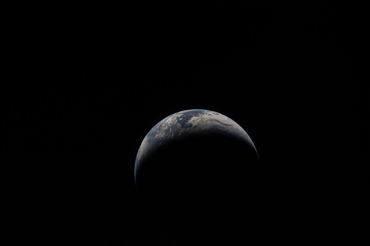
- A crescent Earth captured through the windows of the Orion spacecraft by the Artemis II crew, shortly after they set a new record for the farthest humans have ever traveled from the planet as they flew around the far side of the Moon.NASA
When NASA’s Apollo 8 crew rounded the far side of the Moon in 1968 and astronaut Bill Anders snapped a picture of Earth peeking above the gray horizon, the image became a symbol of hope in challenging times. The photograph, Earthrise, as it came to be called, helped inspire the first Earth Day celebration two years later.
This year, the astronauts of the Artemis II mission captured their own poignant images of home. The newly released photo shows Earth on April 6, as the crew traveled farther than any humans before them.
“On Earth Day, we are reminded of the extraordinary responsibility we share to understand our planet,” said NASA Administrator Jared Isaacman. “NASA’s Earth science missions continue to deliver critical data that strengthen communities, support industries like agriculture, and help the nation anticipate and respond to wildfires, droughts, flooding, and other natural hazards. Together with our Earth science partners, NASA is committed to deepening our understanding of Earth.”
Left: Earthrise on Dec. 24, 1968, memorialized by the Apollo 8 crew in Kodak Ektachrome color film. Right: A crescent Earth hovers just above the lunar surface, minutes before Earthset. This photo was captured on April 6, by the Artemis II crewmembers through the windows of the Orion spacecraft shortly before they flew behind the Moon and journeyed farther from Earth than any other humans have traveled.NASAFrom cameras pressed against spacecraft windows to the most powerful radar ever flown, imaging technology has taken giant leaps since 1968, but the drive to understand our home in the cosmos has remained.
“Our four Artemis II astronauts — Reid, Victor, Christina and Jeremy — took humanity on a journey that showed us just how special and bright our Earth is, even from the dark side of the Moon, that is especially worth celebrating on Earth Day,” said Nicky Fox, associate administrator of the Science Mission Directorate at NASA Headquarters in Washington. “Seeing the incredible images of our blue marble planet over time from Apollo 8’s Earthrise to Artemis II’s Earthset, it is not only a symbolic moment of beauty, but like the other images captured during the lunar flyby, Earthset is brimming with incredible science in high definition that will help inform our future Artemis missions on the Moon.”
Here’s a look at how NASA’s view of Earth has advanced since that early image of the planet.
Sea level to soaring
A photograph of the greater New Orleans area, including Lake Pontchartrain and its nearly 24-mile causeway, taken by the Apollo 7 crew (left) in 1968. Right: an image created using recent NASA-ISRO Synthetic Aperture Radar (NISAR) data. The various colors indicate wetlands, city streets, and other kinds of land cover, which reflect radar signals differently.NASA/JPL-CaltechIn 1968, during their 120th revolution around the planet, the Apollo 7 astronauts snapped a photo of New Orleans, visible amid the green wetlands and tan sediment of the Mississippi River Delta, some 95 nautical miles below. Today, space-based radar is revealing how the earth beneath our feet is rising, sinking and sliding.
Launched in July 2025 by NASA and the Indian Space Research Organisation (ISRO), NISAR’s (NASA-ISRO Synthetic Aperture Radar) L-band and S-band SAR instruments can penetrate clouds and tree canopies to reveal details of Earth’s surface and observe changes. That’s actionable information for communities, including low-lying cities at risk of losing ground due to rising seas and subsiding land.
The NISAR mission continues a long legacy of Earth-observing satellites. Around the globe, from ice to deserts, NASA’s satellite record has chronicled changes to the human and natural world for decades. See how the recently launched PACE (Plankton, Aerosol, Cloud, and Ocean Ecosystem) satellite captured the Mississippi River Delta swirling with marine life.
“The Artemis photos shared with all of humanity the breathtaking beauty of our home planet, as it can only be seen from space,” said Karen St. Germain, division director, NASA Earth Science Division. “NASA’s fleet of Earth science satellites provide additional dimensions to this beauty, by teaching us how our planet supports the vibrant and dynamic forms of life we see on Earth. This data and discovery help us deliver actionable science so we can continue to thrive on our ever-changing planet.”
Reaching new heights
The lofty Himalaya as seen by a Mercury astronaut from his capsule(left) and the Spaceborne Imaging Radar-C/X-band Synthetic Aperture Radar (SIR-C/X-SAR) aboard the space shuttle Endeavour in 1994. Mount Everest is the bright spike right of center in the space shuttle image.NASA/JPLThe Himalaya Mountains have captivated astronauts since the early days of the Space Age. Equipped with a handheld 70mm Hasselblad camera, L. Gordon Cooper photographed Mount Everest and its towering neighbors in 1963 while orbiting the planet 22 times alone in his Mercury-Atlas 9 capsule.
By the early 1990s, scientists were tracing the peaks and valleys of the range in spectacular detail using radar aboard the space shuttle. More recently, other space missions and instruments such as ASTER (Advanced Spaceborne Thermal Emission and Reflection Radiometer) and Landsat have aided high-altitude exploration. They’ve helped scientists pinpoint the location of a deadly avalanche on Mount Everest, and track changing plant life across some of the most remote slopes on the planet.
Eye of storm
Left: Hurricane Gladys as seen by the Apollo 7 astronauts. Right: NASA’s GPM Core Observatory flew over the center of Super Typhoon Sinlaku on April 12, 2026, providing a detailed look into the structure and intensity of the precipitation.NASA’s Scientific Visualization StudioLiftoff of Artemis II on April 1, came exactly 66 years to the day after another milestone launch. The world’s first successful weather satellite — TIROS-1 — sported a pair of television cameras and magnetic tape machines when it rocketed into low Earth orbit in 1960. It provided weather forecasters images of cloud cover from space that improved storm forecasting.
Satellite data complemented the unique photographs captured by Apollo astronauts, who documented hurricanes, thunderheads, and other storm systems roiling beneath their feet. The work continues to this day. Next year, a new generation of radars will take flight as part of the INCUS (Investigation of Convective Updrafts) mission. The three small satellites, flying in tight formation, will help determine why, when, and where severe tropical thunderstorms, heavy precipitation, and clouds occur.
See how a water-watching satellite tracked another kind of natural hazard — a tsunami — speeding across the Pacific Ocean in the wake of a massive earthquake off Russia last July.
Frozen fringes
Left: This photograph captured from SkyLab, NASA’s first experimental space station, helped scientists in the early 1970s survey rugged winter terrain in Eastern Canada. Right: the eastern edge of the Antarctic Peninsula and Drygalski Glacier are pictured from a research aircraft in 2017.NASA/Nathan KurtzThe images above capture two spectacular icescapes a world apart.
The snapshot on the left, taken by a crewmember on the SkyLab space station in 1974, shows plumes of brash ice near Belle Isle off Newfoundland. On the right, new sea ice forms along the coast of Antarctica in an aerial photograph taken during Operation Ice Bridge, NASA’s longest-running airborne mission to observe ice in the North and South polar regions. The findings from that mission, along with satellite laser data, have helped scientists track changes to polar ice sheets since 2003.
In the Arctic, satellites are continually observing how far sea ice retreats season by season and year over year, recording a decades-long trend of less ice cover. On the other side of the globe, in Antarctica, NASA’s MODIS (Moderate Resolution Imaging Spectroradiometer) instrument recently captured the start of summer in full color.
Night, day
The Strait of Gibraltar, where the Atlantic Ocean meets the Mediterranean Sea, photographed from the Gemini-5 spacecraft in 1965 (left) and by crew members on the International Space Station in 2014 (right). Astronauts must regularly change out the space station’s cameras because the radiation in space can damage them.NASA/Alex GerstPicturing Earth as a blue marble tells only part of our story. Earth at night also teaches us a lot about humanity. Sensors orbiting our planet can resolve light sources down to the scale of a toll booth on a dark highway. By tracking night light illumination, scientists, policymakers and industry can map urban growth, electricity use, and economic activity across the planet.
Compare, for example, the Apollo 11 crew’s view of a shrouded Earth on the day that Neil Armstrong and Buzz Aldrin landed on the Moon in 1969, and this new data visualization based on more than 1 million satellite observations taken every night for nine years.
Left: Apollo 11 command module pilot Michael Collins’ view of Earth on July 20, 1969. Right: a high-resolution visualization created using data from the Visible Infrared Imaging Radiometer Suite (VIIRS) sensors.NASA/Michala Garrison For NASA Earth ObservatoryTo explore thousands of more photographs, visualizations, videos, and diagrams shared by NASA throughout its history, visit:
Images.nasa.govCropping and contrast on some images in this story have been adjusted.
-Sally Younger
About the Author
Sally Younger
Share
Details
Last Updated Apr 22, 2026Related Terms
Explore More
3 min readBelts of Green in the Washington Suburbs
Along the northeast side of the Capital Beltway in Maryland, green spaces weave through the…
Article 11 hours ago 1 min readNew NASA Views of Earth, From (S)PACE
NASA has a fleet of satellites in orbit, gathering data around the clock, to explore…
Article 18 hours ago 4 min readA School of Mud Volcano Islands in Azerbaijan
The tadpole-shaped islands along the Absheron Peninsula were born by explosive mud volcano eruptions and…
Article 1 day ago Keep ExploringDiscover More Topics From NASA
Earth
Your home. Our Mission. And the one planet that NASA studies more than any other.
Earth Observatory
NASA's Earth Observatory brings you the Earth, every day: images, stories, and discoveries about the environment, Earth systems, and climate.
Explore Earth Science
Earth Science in Action
NASA's unique vantage point helps us inform solutions to enhance decision-making, improve livelihoods, and protect our planet.