3 min read
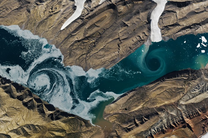
Cañon Fiord’s Whirling WatersImage of the Day for March 16, 2026During the 2022 summer melt season, sediment plumes and fractured sea ice traced swirling eddies in a branch of the Nansen Sound fjord system in the Canadian Arctic.
NASA Earth Observatory
Mar 16, 2026 ArticleFor most of the year, ice blankets the waterways of the northern Canadian Arctic Archipelago. But during the brief summer melt season, the stark white and gray landscape transforms into a colorful, dynamic environment. On a particularly striking day in 2022, sediment plumes and fractured sea ice traced swirling eddies in a branch of the Nansen Sound fjord system.
These satellite images show a section of Cañon Fiord, located about 115 kilometers (70 miles) southeast of the Eureka research station on west-central Ellesmere Island. Waters from the fjord flow into Greely Fiord, which connects to Nansen Sound and ultimately the Arctic Ocean. The images were acquired by the OLI (Operational Land Imager) on Landsat 8 on August 9, 2022.
Igor Dmitrenko, a physical oceanographer at the Centre for Earth Observation Science at the University of Manitoba, has studied eddies in the fjord system and notes that the water’s turbidity, a measure of its cloudiness, remains low during the ice-covered season. Freshwater runoff—and the sediment it carries—drops sharply this time of year, and the formation of 2-meter-thick sea ice shields the surface from wind, suppressing mixing that would otherwise resuspend particles.
Summer presents a contrasting scenario. The detailed image below (top) shows that the sea ice in this part of the fjord has broken up, free to drift with the currents and wind. Note that some of the pieces are likely icebergs that have broken off from nearby outlet glaciers. The second detailed image shows a similar scenario; however, in this case, it is sediment suspended in the water that is tracing the flow.
August 9, 2022 August 9, 2022Alex Gardner and Chad Greene, glaciologists at NASA’s Jet Propulsion Laboratory, pointed out that the sediment plume is mostly glacial flour—rock that has been pulverized by a glacier. Surface meltwater that gets under the glacier ultimately flushes the glacial flour into the fjord, making the water appear turquoise. Glacial flour is a critical source of nutrients, specifically iron. Soluble iron is a vital nutrient in marine ecosystems because most phytoplankton—the foundation of marine food webs—depend on it to grow.
The glacial ice visible in these scenes comes from the Agassiz Ice Cap, one of five major ice caps on Ellesmere Island. Using data from NASA’s ICESat and the DLR-NASA GRACE missions, scientists have shown that glaciers in the Canadian Arctic Archipelago began shrinking rapidly in the mid-2000s and that the trend has persisted.
NASA Earth Observatory images by Lauren Dauphin, using Landsat data from the U.S. Geological Survey. Story by Kathryn Hansen.
Downloads
View AllAugust 9, 2022
JPEG (11.98 MB)
References & Resources
- Dmitrenko, I.A., et al. (2025) Following a half-century oceanographic data gap in the northern Canadian Arctic Archipelago: multidecadal variability of the Pacific water throughflow. Frontiers in Marine Science, 12, 1602485.
- Gardner, A.S., et al. (2011) Sharply increased mass loss from glaciers and ice caps in the Canadian Arctic Archipelago. Nature, 473, 357-360.
- Wouters, B., et al. (2019) Global Glacier Mass Loss During the GRACE Satellite Mission (2002-2016). Frontiers in Earth Science, 7, 96.
You may also be interested in:
Stay up-to-date with the latest content from NASA as we explore the universe and discover more about our home planet.
Arctic Sea Ice Ties for 10th-Lowest on Record 3 min readSatellite data show that Arctic sea ice likely reached its annual minimum extent on September 10, 2025.
Article Stonebreen’s Beating Heart 3 min readThe glacier in southeastern Svalbard pulses with the changing seasons, speeding up and slowing its flow toward the sea.
Article Antarctic Sea Ice Saw Its Third-Lowest Maximum 2 min readSea ice around the southernmost continent hit one of its lowest seasonal highs since the start of the satellite record.
Article Keep ExploringDiscover More from NASA Earth Science
Subscribe to Earth Observatory Newsletters
Subscribe to the Earth Observatory and get the Earth in your inbox.
Earth Observatory Image of the Day
NASA's Earth Observatory brings you the Earth, every day, with in-depth stories and stunning imagery.
Explore Earth Science
Earth Science Data
Open access to NASA’s archive of Earth science data