3 min read
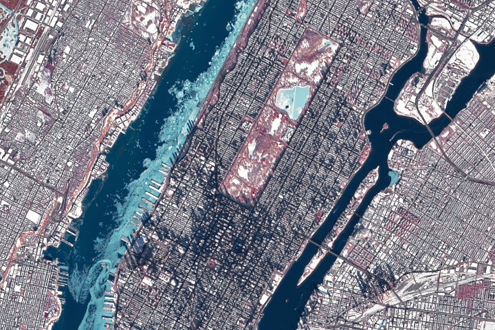
Chilled New York CityImage of the Day for February 4, 2026Ice in the Hudson River hugged the shore of Manhattan amid a deep freeze.
NASA Earth Observatory
Feb 04, 2026 ArticleThe New York metropolitan area was showing the effects of a prolonged cold spell in late January 2026. During a stretch of frigid weather, ice choked the Hudson River along Manhattan’s western shore.
The OLI (Operational Land Imager) on Landsat 8 captured this image of the wintry landscape around midday on January 28. The image is false-color (bands 5-4-3) to distinguish ice (light blue) from open water and snow. Vegetation appears red. Ice is abundant in the Hudson River and visible in smaller amounts in the East River, the Jacqueline Kennedy Onassis Reservoir in Central Park, and waterways in New Jersey.
Temperatures in New York City dropped below freezing on January 24 and stayed there for over a week. The high on January 28, the date of the image, was 23 degrees Fahrenheit (minus 5 degrees Celsius). Low temperatures and harsh wind chills gripped much of eastern North America over this period amid a surge of Arctic air.
Much of the ice in the image likely floated there from farther upriver, where tidal currents are weaker and salinity is lower. These conditions allow water to freeze sooner and at higher temperatures than the faster-flowing, brackish water near the river’s mouth, shown here. A complete freeze of the Hudson around Manhattan is unlikely, experts say, although it did occur back in 1888. Still, the ice buildup was substantial enough for NYC Ferry to suspend services for several days.
Iced-up rivers can have other implications, from flooding and infrastructure damage to changes in hydrologic processes that affect water quality and aquatic habitats.
Scientists, government agencies, and emergency responders are increasingly turning to remote sensing technologies such as