Zoom
View of Carratraca from the halfway point of the ascent J. Amellones Malaga escapade Climbing to the peak of El Grajo: The natural viewpoint overlooking the heart of MalagaFrom Carratraca you can climb to this summit, officially known as Valdivia, which is situated almost 1,300 metres above sea level
Malaga
Monday, 27 April 2026, 08:52
An unofficial but very popular trail that climbs up to the highest part of the Alcaparaín mountain range, between Carratraca, Ardales and Casarabonela, in the area bordering the Sierra de las Nieves natural park.
Route information
Comarcas: Guadalteba y Sierra de las Nieves
Municipalities: Carratraca and Casarabonela
Difficulty level: Medium-High. Progressive ascent with zigzagging sections that soften the slope. It is not an approved path and you will have to watch out for the classic stone cairns in many sections.
Type of route: Linear
Approximate duration: Three hours and 15 minutes (one way).
Length: 6.9 kilometres (one way).
Minimum height: 620 metres.
Maximum height: 1,293 metres.
Nearby places of interest: Puerto Martínez, Pico Grajo or Valdivia, Carratraca town centre (Historic-Artistic Site), Nuestra Señora de la Salud church, Thermal Baths (currently closed to the public), Casa de Trinidad Grund (Town Hall) and the old bullring dug out of the rock.
Zoom
The summit of El Grajo (the rook) as seen from the Casa Trinity Grund. J. AmellonesHow to get to the starting point
Take the A-357 (Malaga-Campillos) as far as Carratraca . Just before entering the village, there is a dirt track flanked by cypress trees (part of this road coincides with a stage of the Gran Senda de Málaga) that leads to an esplanade next to a water reservoir and a heliport, where you can park your car, as long as you allow other vehicles to circulate in the area.
Route description
1The route starts next to the water reservoir and the heliport, in a relatively comfortable environment. The wide track soon appears and begins to gradually gain height. One of the great successes of this route is its zigzagging route, which allows you to tackle the gradient without any major problems. However, you will have to be careful at one of the sharp turns in the path to take a narrow path. To do this, look out for the classic stone cairns that mark the exact spot where you leave the track to start walking along a narrow path.
Zoom
After the wide lane, turn off onto a narrow path. J. Amellones2Through this narrow path begins one of the most thrilling parts of this route. After crossing a small pine forest, the path heads towards an area where, as you gain height, the terrain changes. The vegetation clears and the limestone formations that are so characteristic of the Alcaparaín mountain range begin to appear. Erosion has sculpted whimsical figures: natural arches, stones reminiscent of animals or human silhouettes, giving the route an almost fantasy feel.
Zoom
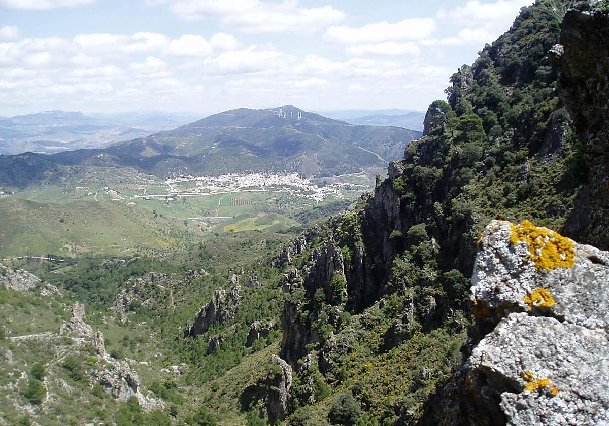
Geological formations on the first zigzag ascent J. Amellones3After a climb that is lessened by the zigzagging, but intense, we reach 1,150 metres above sea level, which makes the rest of the climb to the summit much more bearable. In fact, there is a good stretch where there is hardly any difference in altitude. The direction of the route also changes. At the height of Sierra Canana, which lies to the west, you take a path that heads south to link up with the Alcaparaín pass, where there is an important crossroads, which could be used, for example, to head towards neighbouring Casarabonela.
Zoom
The first half of the route is the one with the steepest gradient. J. Amellones4From the Alcaparaín pass junction you walk for about a kilometre and a half along a wide track that heads south. The road here is not only flat but even starts to descend. Watch out for a change of direction on this track to turn off onto a narrow path that heads towards the summit of El Grajo or Valdivia. Here the signposting again depends on the classic stone cairns that have traditionally been used to indicate these detours.
Zoom
Geology leaves its mark, like here J. Amellones5One of the most demanding sections of the route begins on the narrow, stony path. In addition to the accumulated fatigue and the difference in altitude to be tackled (almost 200 metres in just over a kilometre), it is also difficult to find your way around. For this reason, it is a good idea to carry a map or mobile app so as not to get lost. All this effort is rewarded when you reach the summit, located 1,293 metres above sea level. This peak offers one of the most complete panoramic views of the interior of Malaga. From here you can see a large part of the Guadalteba Valley, the Hoya de Málaga and the Sierra de Huma. It is also possible to see some of the reservoirs located next to the latter mountain range. Moreover, this peak has a unique history: it officially bears the name of Valdivia, in memory of the topographer Juan Valdivia, who died in this enclave in 1984. To return, you can use the same path or take the track taken from the Alcaparaín pass to continue descending. In this way, you will also reach the starting point.
Zoom
Valdivia Peak, popularly known as El Grajo J. AmellonesFlora and fauna
If there is one tree species that stands out, it is the pine (including the Aleppo pine), which is abundant at certain points along the route. However, at the same time, you can also see typical scrubland and even steppe vegetation. Among the tree species that can also be seen are holm oaks, wild olive and carob trees. This trail can also be very interesting, especially in its final stretch, due to the abundance of native fauna. So, flying over the high part you can see corvids, such as choughs, birds of prey, such as kestrels and Bonelli's eagles, or even the most abundant scavengers in the province of Malaga, the griffon vultures. Among the mammals, you can occasionally see mountain goats.
Zoom
In addition to the reforestated pine forest, there is a wide variety of Mediterranean scrub along the route. J. Amellones