3 min read
Eruption at MayonImage of the Day for March 13, 2026Activity at the volcano in the Philippines sent lava and pyroclastic flows down the volcano’s flanks and prompted evacuations in nearby communities.
NASA Earth Observatory
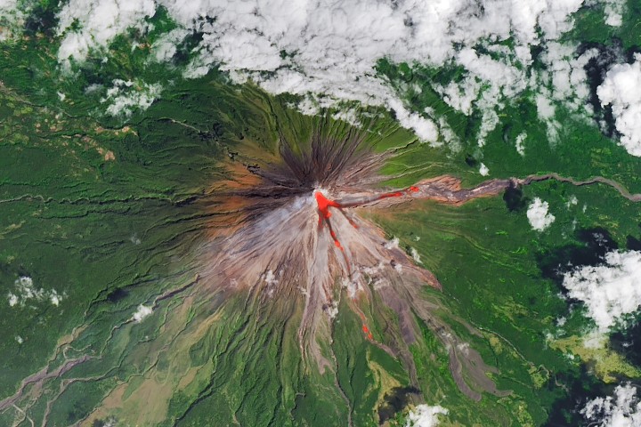
Mar 13, 2026 ArticleAt any given moment, about 20 volcanoes on Earth are actively erupting. Often among them is Mayon—the most active volcano in the Philippines. The nearly symmetrical stratovolcano, on Luzon Island near the Albay and Lagonoy gulfs, rises more than 2,400 meters (8,000 feet) above sea level.
Historical Philippine Institute of Volcanology and Seismology (PHIVOLCS) first reported increased rockfalls near the volcano’s summit and inflation of the mountain's upper slopes. On January 6, the alert level was increased to three on a five-level scale after lava began flowing from the crater and hot clouds of ash and debris called pyroclastic flows (also called pyroclastic density currents) moved down one side of the mountain.
The volcano was still puffing and lava flowing on February 26, when the OLI (Operational Land Imager) on Landsat 8 acquired this rare, relatively clear image. The natural-color scene is overlaid with infrared observations to highlight the lava’s heat signature. On that day, PHIVOLCS reported volcanic earthquakes, rockfalls, and pyroclastic flows. The longest pyroclastic flow had traveled about 4 kilometers (3 miles) through the Mi-isi Gully on the southeast flank.
The level-three alert, which remained in place in March, prompted evacuations within a 6-kilometer (4-mile) radius of the crater, displacing hundreds of families from communities including Tabaco City, Malilpot, and Camalig. Past pyroclastic flows have proven extremely destructive, leading to more than 1,000 deaths in 1814, at least 400 deaths in 1897, and 77 deaths in 1993. More than 73,000 people were evacuated during an eruption in 1984.
Sulfur dioxide (SO2) emissions during the current eruption have averaged 2,466 tons per day, with a peak of 6,569 metric tons measured on February 4, 2026. That is the highest SO2 emission level for one day in 15 years, the 7,633 metric tons.
Multiple NASA satellites have also monitored the volcano’s sulfur dioxide emissions, showing sizable plumes of the gas drifting southwest on February 4 and March 6. The Philippine volcanology institute reported a peak in other activity on NASA Earth Observatory image by Michala Garrison, using Landsat data from the U.S. Geological Survey.Story by Adam Voiland. JPEG (3.86 MB) Stay up-to-date with the latest content from NASA as we explore the universe and discover more about our home planet. Downloads
February 26, 2026
References & Resources
You may also be interested in:
In its first documented eruption, the Ethiopian volcano sent a plume of gas and ash drifting across continents.
Article Krasheninnikova Remains Restless 3 min readThe volcano on Russia’s Kamchatka Peninsula continues to erupt after centuries of quiescence.
Article A Hot and Fiery Decade for Kīlauea 6 min readThe volcano in Hawaii is one of the most active in the world, and NASA tech makes it easier for…
Article Keep ExploringDiscover More from NASA Earth Science
Subscribe to Earth Observatory Newsletters
Subscribe to the Earth Observatory and get the Earth in your inbox.
Earth Observatory Image of the Day
NASA's Earth Observatory brings you the Earth, every day, with in-depth stories and stunning imagery.
Explore Earth Science
Earth Science Data
Open access to NASA’s archive of Earth science data