2 min read
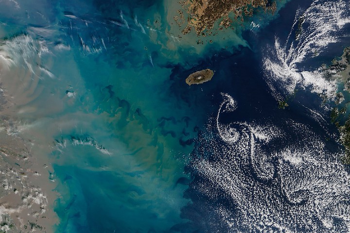
Showy Swirls Around Jeju IslandImage of the Day for February 24, 2026Winds blowing past the volcanic landmass near the Korean Peninsula created a trail of spiraling clouds, while murky water churned nearby.
NASA Earth Observatory
Feb 24, 2026 ArticleThe tallest point in South Korea is not located in the Taebaek Mountains that run along the country’s eastern coast. Rather, it is found atop a volcanic peak on Jeju Island, about 100 kilometers (60 miles) south of the Korean Peninsula. In winter 2026, winds blew past the island in just the right way to send clouds spinning in its wake.
The MODIS (Moderate Resolution Imaging Spectroradiometer) on NASA’s Terra satellite captured this image of swirling clouds—and colorful, turbulent water—near Jeju Island on February 19, 2026. The island rises about 1,950 meters (6,400 feet) above the sea surface. At its center is Hallasan, a shield volcano that last erupted in the 11th century and contains a notable network of lava tubes.
The trailing, staggered spirals, called von Kármán vortex streets, form when a fluid passes a tall, isolated, stationary object. If winds are too weak, clouds simply flow smoothly past, and if winds are too strong, vortices cannot maintain their shape. In the sweet spot, with winds between 18 and 54 kilometers (11 and 34 miles) per hour, clouds trace the airflow in patterns of counterrotating vortices. Though the underlying physics is the same, the appearance of the vortices can vary: sometimes they look wispy, as they do here, and other times they form more sharply defined, parallel rows, as they did at the same location the previous day.
The seas, as well as the atmosphere, were turbulent near Jeju Island in mid-February. To the west, a large plume of sediment coming off the coast of China’s Jiangsu province turned waters murky. While brown, sediment-laden water is present in the shallow nearshore area year-round, expansive plumes like this one are common during winter. Research suggests that seasonal changes in currents and vertical mixing of the water column may account for the large winter plumes.
NASA Earth Observatory image by Michala Garrison, using MODIS data from NASA EOSDIS LANCE and GIBS/Worldview. Story by Lindsey Doermann.
Downloads
February 19, 2026
JPEG (2.74 MB)
References & Resources
- Global Volcanism Program, Halla. Accessed February 23, 2026.
- NASA Earth Observatory (2024, February 24) Sediment Fans Out Over the Yangtze Bank. Accessed February 23, 2026.
- NASA Earth Observatory (2008, November 16) Cheju Island, South Korea. Accessed February 23, 2026.
- UNESCO World Heritage Convention (2018) Jeju Volcanic Island and Lava Tubes. Accessed February 23, 2026.
- Weather Underground (2019, December) Whirls, Curls, and Little Swirls: The Science Behind Von Karman Vortices. Accessed February 23, 2026.
You may also be interested in:
Stay up-to-date with the latest content from NASA as we explore the universe and discover more about our home planet.
Islands of Fire and Ice Veiled in Cloud 3 min readPuffs of low-level clouds mingle with the volcanic terrain of Candlemas and Vindication islands in the remote South Atlantic.
Article A Plume of Bright Blue in Melissa’s Wake 5 min readThe category 5 hurricane stirred up carbonate sediment near Jamaica in what scientists believe is the largest such event in…
Article Puerto Rico From Above 4 min readAn astronaut photographed the island’s striking mix of mountains, forests, and expanding urban areas.
Article Keep ExploringDiscover More from NASA Earth Science
Subscribe to Earth Observatory Newsletters
Subscribe to the Earth Observatory and get the Earth in your inbox.
Earth Observatory Image of the Day
NASA's Earth Observatory brings you the Earth, every day, with in-depth stories and stunning imagery.
Explore Earth Science
Earth Science Data